 CNR-ISMAR
National Research Council (CNR)
Type of resources
Available actions
Topics
INSPIRE themes
Provided by
Years
Formats
Representation types
Update frequencies
status
Scale
-

Dati registrati da idrofoni nell'ambito del progetto Interreg SOUNDSCAPE
-
Siti di campionamento della rete di monitoraggio ai sensi della direttiva 2000/60 nella laguna di Grado e Marano nel I e II triennio. Qualità delle acque marino-costiere e di transizione
-
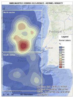
The MAELSTROM Project performed a literature survey includes existing databases on marine litter data on the water column, sea floor, estuaries, rivers and beaches. Specifically, the European/Regional Seas review is based on existing publications while the study areas review is based on existing publications and raw data, when available. The review intends to provide the knowledge-base on the characteristics, sources and pathways of marine litter in the two demo sites of the lagoon of Venice (Italy) and the Ave River estuary (Portugal). Specifically, the review aims at: ● improving the understanding of the amounts and types of marine litter occurring in Europe and in particular in the study areas; ● improving the understanding of the main sources and pathways of marine litter in Europe and in particular in the study areas; ● supporting the definition of the input data and assumptions related to marine litter to be used in numerical models of marine litter spatial distribution. To achieve this objective, we assume the following constraints: ● the main focus is on macro-litter; ● the review has a geographic scope focused on the study sites; ● marine litter literature has been analysed to indicate the most probable sources and amount. Here the results related to the NW Portuguese coastal area. For more details, see the project deliverable: Ghezzo, M., MOSCHINO, V., Galvez, D., Mira Veiga, J., Bocci, M., Iglesias, I., Vieira, L., Sousa Pinto, I., Antunes, S. C., & Correia, A. M. (2021). D2.1 Report on the characterization of major sources of marine litter and macro-plastic in the demo sites. MAELSTROM Project. https://doi.org/10.5281/zenodo.14920205
-
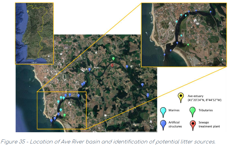
The MAELSTROM Project performed a literature survey includes existing databases on marine litter data on the water column, sea floor, estuaries, rivers and beaches. Specifically, the European/Regional Seas review is based on existing publications while the study areas review is based on existing publications and raw data, when available. The review intends to provide the knowledge-base on the characteristics, sources and pathways of marine litter in the two demo sites of the lagoon of Venice (Italy) and the Ave River estuary (Portugal). Specifically, the review aims at: ● improving the understanding of the amounts and types of marine litter occurring in Europe and in particular in the study areas; ● improving the understanding of the main sources and pathways of marine litter in Europe and in particular in the study areas; ● supporting the definition of the input data and assumptions related to marine litter to be used in numerical models of marine litter spatial distribution. To achieve this objective, we assume the following constraints: ● the main focus is on macro-litter; ● the review has a geographic scope focused on the study sites; ● marine litter literature has been analysed to indicate the most probable sources and amount. Here the results related to the Ave estuary Portuguese demonstration site. For more details, see the project deliverable: Ghezzo, M., MOSCHINO, V., Galvez, D., Mira Veiga, J., Bocci, M., Iglesias, I., Vieira, L., Sousa Pinto, I., Antunes, S. C., & Correia, A. M. (2021). D2.1 Report on the characterization of major sources of marine litter and macro-plastic in the demo sites. MAELSTROM Project. https://doi.org/10.5281/zenodo.14920205
-
Dati per le stazioni di monitoraggio ai sensi della direttiva 2000/60 nelle acque della laguna di Venezia. Sono disponibili i dati di abbondanza per taxa.
-
Dati di livello di pressione sonora ottenuti elaborando file wav di rumore subacqueo registrati nell'ambito del progetto Interreg SOUNDSCAPE.
-
Dati per le stazioni di monitoraggio ai sensi della direttiva 2000/60 nelle acque di transizione del Veneto (esclusa la laguna di Venezia). Sono disponibili i dati di presenza per taxa.
-

Benthic habitat map of the Southern Adriatic Sea (Mediterranean Sea) from Object-Based Image Analysis of Multi-Source Acoustic Backscatter Data. Scale 1:300.00. Authors: Prampolini M., Angeletti L., Castellan G., Grande V., Le Bas T., Taviani M., Foglini F.
-
The bathymetry was acquired in 2013 in the Grand Canal (Venice) as part of the RITMARE (La Ricerca ITaliana per il MARE) research project. The data were collected using a Kongsberg EM-2040 dual-head multibeam system operating at 360 kHz, mounted on the CNR Litus vessel, and subsequently processed with Kongsberg SIS software. The information acquired was integrated with sound velocity profiles and georeferenced using the Seapath 300 positioning system. This survey will serve as a basis for comparison with data collected ten years later, in 2023, in order to assess any morphological and sedimentological changes in the bottom of the Grand Canal.